

Murray Wood: The most important documents in your house probably aren't the ones you think of first
As Murray Wood explains, the most important pieces of paper in our lives are often buried in a drawer or a box in a clos...
The Land of the Living Skies will really be moving this week, as a low-pressure system moving in from Alberta is expected to travel through Saskatchewan.
Environment Canada issued a number of yellow winter storm watches on Monday saying that the system will arrive Tuesday morning and finally move out of the province on Wednesday.
Read more:
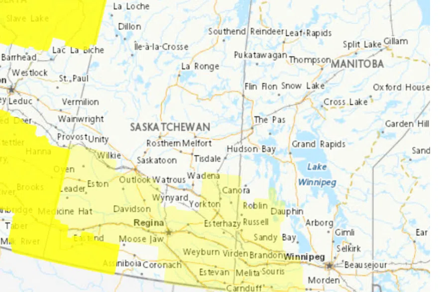
The weather map for Saskatchewan on Dec. 8, 2025 shows Environment Canada’s new colour-coded alert system, with moderate warnings shown in bright yellow and moderate watches in pale yellow. (Enmvironment Canada website)
Environment Canada is using new colour-coded alerts. Every type of weather alert — warnings, advisories, and watches — now has a colour when it is issued moving from yellow, to orange and then red as the potential risk increases.
The weather agency says yellow alerts are the most common and identify when hazardous weather may cause damage, disruption, or health impacts. Yellow alerts identify moderate, localized and/or short-term weather.
This week’s weather is expected to bring a mix of different conditions, with everything from freezing rain to strong winds and snow.
On Monday, yellow Environment Canada’s winter storm watches covered a majority of the province south of communities like Canora and Kerrobert.
Environment Canada meteorologist Christy Climenhaga said that this week’s weather system will cause some unfortunate combinations.
“It’s a really complicated system, with warmer temperatures, even some rainfall to start off with in parts of the southwest, a freezing rain risk through parts of west central and then southeastern Saskatchewan, and then snowfall a little bit further to the north,” she said.
She said that the weather will change drastically depending on where people are in the province.
“For Saskatoon you’re looking at the risk of some snow … and then some strong winds as well with this system,” she said.
As for areas like Regina, it will be a very different situation.
“When we’re dealing with rain, then a very cold temperature happens very quickly, you get ice forming,” said Climenhaga.
“So likely, very slippery conditions, especially on roads along that freezing rain line, stretching around the Kerrobert area, down southeast, through Regina, then through Estevan,” she said.
Yellow alert winds are also in this week’s forecast, with Environment Canada calling for the possibility of strong winds and snow squalls in the southwestern corner of the province that if, mixed with flurries or rain showers, could cause issues with visibility.
Tuesday’s storm is expected to move out of the province by Wednesday, but an Arctic air mass is expected to drop into the province immediately afterward, bringing temperatures far below what the province typically sees in early December.
Seasonal highs for this time of year are around -10 C across the southern half of the province. This week, many communities will see daytime highs between -15 C and -20 C, with overnight lows dipping to around -25 C.
— with files by CJME News
Read more: