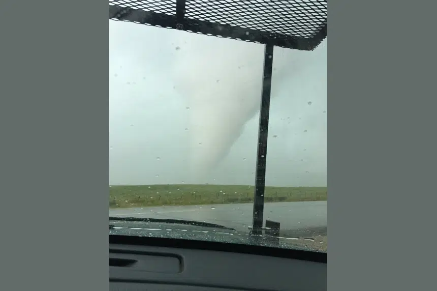
Severe weather interrupted many people’s long weekend on Sunday, with tornado-producing storms that lasted hours.
Severe thunderstorm watches were first issued around noon, and warnings started popping up around 2 p.m. Shortly after 4 p.m. Environment Canada confirmed a tornado had touched down northwest of Melville and was tracking northeast. Environment Canada told the Canadian Press that tornado ripped apart a barn, trees and tossed bins and bails about.
A second tornado touched down about five kilometres away around 5:20 p.m., according to Environment Canada – it destroyed a modular home, but the family inside was able to escape.
Katie Vickers was right in the thick of things. She’s a stormchaser and trained storm-spotter. Her evening started just west of Melville where she spotted the first tornado of the night.
“We had some intense roatation right above us, and then it just actually passed maybe about 100 yards just to the east of us. And then it went into a field and it actually dropped down a couple of funnels right then and there.”
One photo Vickers posted on social media is incredibly close to a tornado and she said it was wrapped in rain so they didn’t see it at first.
“We were getting hit with some pretty big-time winds, and we were kinda’ concerned of where exactly the tornado was going to be, and I all of a sudden just kind of looked and I’m like ‘um, it’s right there.'”
She said the amount of storm activity isn’t surprising for this time of year, but she didn’t think it was going to be as intense as it was.
For Vickers, Sunday night is in her ‘Top 3’ of storm chasing.
“First off, I’ve never been that close to a tornado. Structure-wise, as a photographer, the colouring was beautiful, I’ve never seen a storm quite like it.”
The storms brought heavy rains and large hail with it. There were reports of toonie-sized hail on the Peepeekisis First Nation, and small hail in Esterhazy.
After the tornado passed by, Yorkton got hit with heavy rain – some areas reporting 60 mm in an hour. Photos and video on social media showed flooded roads and parking lots in that city. Hail the size of tennis balls belted the Yorkton area as well.
Environment Canada was investigating a third unconfirmed tornado near Camperville, Manitoba, Sunday night.
With files from The Canadian Press.
Trying to wrap up again north of Melville. 4:32 #skstorm pic.twitter.com/B4TsoRLHMt
— Sean Schofer (@SeanSchofer) July 31, 2016
Wall cloud forming on storm southwest of Melville, SK 5pm #skstorm pic.twitter.com/F4w5H0NsO4
— Craig Hilts (@CraigHilts71) July 31, 2016
Camera kept focusing on the window but here’s a suspicious cloud between Balcarres and Melville #skstorm pic.twitter.com/TrC9NvpGfn
— David (@davidmclennan91) July 31, 2016
South of Yorkton on Highway 9. 5:22pm Storm is moving ENE. #skstorm pic.twitter.com/HZCRAAEDH9
— Katie Vickers (@katielyn_213) July 31, 2016
July 31 526pm – 7 miles east of Melville SK #skstorm pic.twitter.com/xcACzEllWn
— Dustin Freeman (@DusterMB) July 31, 2016
Yorkton storm producing some pretty big hail #skstorm @weathernetwork pic.twitter.com/Iopmg9Amt1
— TristaDzuba (@trista_dzuba) July 31, 2016
@GX94Radio @weathernetwork Flooding in Yorkton right now! With toonie sized hail!! #skstorm @ctvregina @CTVYorkton pic.twitter.com/1xOwkjTt1d
— Jennifer Haas (@msjenniferhaas) July 31, 2016
@weathernetwork @TornadoGreg Broadway Street, Yorkton #skstorm #Yorkton pic.twitter.com/FW2CCN9kVa
— Amanda Uhryn (@auhryn) August 1, 2016


