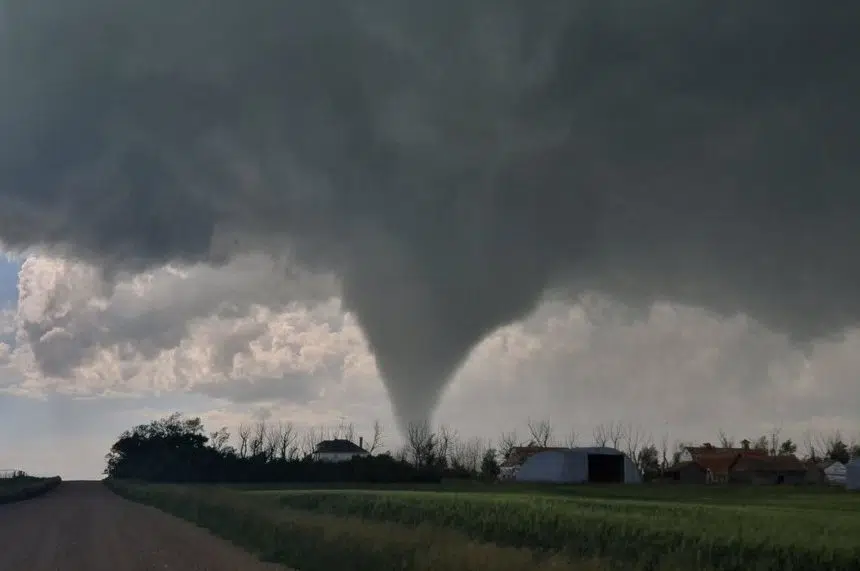
A gorgeous summer day in southwest Saskatchewan ended with residents being told to stay inside after severe weather rolled through the region on Saturday.
A storm chaser confirmed that at least a pair of tornadoes touched down in the afternoon.
Craig Hilts spoke to 980 CJME and 650 CKOM from Highway 13 just north of Meyronne.
Hilts had been tracking a severe thunderstorm from Vanguard. He spotted some rotation before the storm appeared to dissipate.
“All of a sudden it pulled everything together and the clouds were spinning really, really quick and it just slowly built and built and built and wound up being a large cone tornado,” Hilts said.
Tornado on the ground south of Glenbain, Saskatchewan 4:30pm #SKstorm pic.twitter.com/pZAYzXLNIi
— Craig Hilts (@CraigHilts71) July 4, 2020
The funnel cloud was spotted from about a mile away. During a phone interview, Hilts saw the tornado touch down a second time.
“Pretty much over open field. It actually just crossed the road that we were on and started lifting just out at about that point,” he said.
Second tornado 20km West of Lefleche SK.#skstorm pic.twitter.com/t7uobk8iMT
— Craig Hilts (@CraigHilts71) July 4, 2020
Tornado touch down west of Thomson Lake, Saskatchewan. Time lapse taken at 4:54pm #skstorm pic.twitter.com/HmeD8dEdgY
— Kassi McCabe (@Kassi_Lee) July 4, 2020
There were numerous other witnesses in the southwest, posting photographs and videos of rotating clouds.
Callum Strubel shot one touching down near Thomson Lake.
“There was a huge tornado, then it disappeared for a bit, and then touched down two more times,” Strubel said.
Tornado touchdown south of Assiniboia SK 6:24pm #skstorm pic.twitter.com/635UQr4BBc
— Tia Griep (@wxamorilla7) July 5, 2020
In the early afternoon, tornado warnings had been issued by Environment Canada for regions around Swift Current, Shaunavon, Maple Creek to Cypress Hills.
According to the weather office, radar detected a “tornadic thunderstorm” about 10 kilometres north of Aneroid, heading east.
Cone-shaped #tornado this evening near the village of Woodrow in Saskatchewan, Canada! 🌪🇨🇦
Note the wide debris cloud at it’s base.
Video sent in by: Brian Wegner#weather #stormhour #abstorm #wx pic.twitter.com/I8IPeHcdVi
— Nash from Nashville (@NashWX) July 5, 2020
That storm was expected to produce golf ball-sized hail or larger, and wind gusts higher than 120 kilometres per hour. In Assiniboia, hailstones were seen blanketing yards and decks.
Environment Canada meteorologist Alysa Pederson urged people in those places to stay inside.
“If they’re in the region, we’d recommend they seek shelter inside, maybe in a basement away from windows as the storm passes through,” Pederson said.
Shortly after 7 p.m., the last warnings issued around Assiniboia, Gravelbourg and Coronach were lifted.
Visual of tornado warned storm south of Vanguard, Saskatchewan 3:42pm #SKstorm pic.twitter.com/gjLyrJlWkX
— Craig Hilts (@CraigHilts71) July 4, 2020
Earlier in the day, the weather office called severe thunderstorm watches for most of the province with warnings scattered throughout.
Pederson had seen weak thunderstorms in the Swift Current area, with potential for them to get stronger.
“As the day progresses here and we get a little bit more daytime heating, these storms can actually start to develop a little more strongly, and little more widespread,” Pederson said.

Callum Strubel photographed this tornado near Thomson Lake in southwest Saskatchewan on July 4, 2020. (Photo courtesy @gaygreetnt/Twitter)

Storm clouds observed by Cynthia Blakley-Allan in Swift Current on July 4, 2020. Environment Canada had issued a severe thunderstorm warning and later that day, a tornado warning. (Submitted by Cynthia Blakley-Allan)
The storm is moving east and conditions are looking good on Sunday.
“Overnight, things should clear out and move off into Manitoba … and once they move through, we’re not anticipating too much behind them,” Pederson said.
Severe weather had already been observed this weekend.
On Friday night, the weather office issued tornado and severe thunderstorm warnings for the southern part of the province.
At the Assiniboia weather station, wind gusts were as high as 122 kilometres per hour.


