


Murray Wood: Who's hot... and who's not
Every Friday, Murray Wood takes a look back at the week's news and decides who's hot... and who's not. This week's list ...
The spring thaw is nearing completion, with no more risk of ice jamming and flooding, and some fire bans already are in place in Saskatchewan.
The Saskatchewan Public Safety Agency (SPSA) gave an update on the province’s transition into spring weather Thursday morning.
Chris Clemett, acting executive director for the SPSA, said ice breakup has happened on major rivers and all areas of the province are spring-bound.
In the north, Clemett said there was a heavier snowpack in the winter with cooler temperatures so far this spring, which has led to a slow melt and cleanup season.
Central Saskatchewan has seen an average spring thaw with most areas snow-free for weeks now, though some bush and tree areas do still have snow.
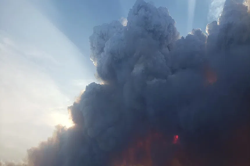
The southern part of the province — with the exception of areas hit by the three major spring storms over the past several weeks — has been without snow for a while and is experiencing higher risks of grass fires.
Risk of those fires will continue until dead and dry vegetation turns green and begins to regrow for the season, Clemett said.
With that dry vegetation, Clemett warned against wildfires — about half of which are started by humans, with the remaining fires usually attributed to lightning. He urged Saskatchewan residents to take precautions at this time of year by cleaning their properties and homes, pruning trees and ensuring that campfires are put out completely.
“When wildfires happen, protecting human life and communities is always the top priority,” Clemett said, “followed by protecting critical public infrastructure, commercial tender, remote structures and natural resources.”
Jeanette Krayetski, manager of intelligence and situational awareness with the SPSA, said it’s hard to predict where the highest risks for wildfires in Saskatchewan will be this year, given how early it is in the wildfire season.
Krayetski said any area that is largely snow-free is a risk now for wildfires.
“Until the vegetation starts to turn green and the leaves on the trees flesh out, it is a very high-risk time for that dry, dormant vegetation to start on fire and those fires, because of Saskatchewan’s spring winds, can quickly become uncontrollable,” she explained.
The wildfire outlook will largely depend on short-term weather trends like extended periods of heat, wind and rain heading more into the spring season.
“We ask people to be extra cautious when they are using any type of open fire,” Krayetski said.
The SPSA’s executive director of land operations, Bryan Chartrand, said the Hudson Bay area is being surveyed after the fire in the area that occurred late last year. He said there is concern because of Saskatchewan’s dry fall last year, and said the agency is predicting some possible starts from zombie fires in the area.
Staff have been out to survey the area and resources are scanning for possible hotspots there, Chartrand reported.
For agriculture purposes, Krayetski said the ground will be drier in the far south and gain moisture moving north.
For fire prevention, she noted the importance of safe burning and the province’s burn notification program for anyone planning a controlled burn near the provincial forest.
Any burns in the provincial forest or within 4.5 kilometres of it are required to provide notification of their burn, according to provincial legislation. That call can be made to a local forest protection office or a fire base, which will ask a list of questions and require information from the individual planning the fire.
They will also consult indices to determine whether conditions are appropriate for a burn.
A controlled burn line is also in effect for individuals planning burns in areas not currently under a fire ban.
Any fires seen within the forest and its 4.5 km border should be reported to 911, Clemett said.
Krayetski said she’s pleased to see people clearing brush and ditches in areas where the snow has melted.
Currently, rural municipalities around the Saskatoon area and some west of Swift Current are under fire restrictions and bans.
Every wildfire in the province is assessed by the SPSA to determine the appropriate response, Clemett said. He noted the magnitude of the response doesn’t necessarily equate to the distance a fire is from a community, however.
“Healthy, vibrant forests are naturally renewed by fire, so under certain circumstances, it makes ecological sense to allow some fires to occur unhindered,” Clemett said.
Responses to such fires in the province will draw on various resources, including helicopters and aircraft. As part of a renewal initiative put in place in 2005, the SPSA is expecting the delivery of two new aircraft this fall, to be put into use next year.
Clemett said 302 seasonal staff have returned to prepare for the upcoming wildfire season and began training last month. They’re completing their training and will be employed until the end of August.
Materials delivered to communities to prepare against flooding, including sandbagging supplies, is now being returned to the SPSA, though it is still available to communities if needed.
Krayetski urged preparedness for whatever the upcoming warm-weather seasons bring for Saskatchewan residents and suggested a readiness plan in case of emergency is made for individuals and families.
Anyone who sees a wildfire or grassfire is asked to call 911.
Krayetski said the SPSA is preparing alongside its own meteorologists and those who work for Environment and Climate Change Canada for storms, tornadoes and other extreme weather that could hit the province through the summer months.
“Early warning is really the key,” Krayetski said, adding the SPSA will make contact with communities that are at a higher risk of extreme weather when they become aware to assist them with preparedness.
Henri Dagenais, the SPSA’s chief meteorologist, confirmed it is a La Nina weather year, which should become more neutral by fall. That means the province should see warmer-than-normal weather from June through September, with about normal precipitation.
Typically, advisories for general areas can be sent out about 24 hours ahead of extreme weather, Dagenais said. However, the exact location for extreme weather is often not known until an event begins, with a watch issued about four to six hours ahead.
Once a cell is active, Dagenais said it is visible on radar, giving the agency about a two-hour window to issue tornado warnings or other major cloud events. Radar in Saskatchewan only reaches up to the south side of La Ronge, with none north of that town. It also extends north up to Buffalo Narrows but does not reach La Loche.
To know the path of something like a tornado, Dagenais said about two hours’ notice can be given. Saskatchewan can see up to about 100 tornadoes in a summer.
Clemett noted the SaskAlert app is the primary source of emergency information in real time for Saskatchewan residents. It will alert individuals and families when they need to protect themselves and how, in case of any significant weather or environmental happenings.


")
